STEADI: intervene
What the Hurricane Cone Really Means for Seniors
The hurricane advisory cone shows where a storm's center may travel, not where danger ends — surge and wind can strike well outside it. This guide decodes the cone for older adults and their caregivers, and translates watches, warnings, and evacuation zones into concrete senior go-or-stay steps.
If you are looking at a TV or phone graphic and asking whether an older adult is “in the cone,” start with this: the hurricane advisory cone shows where the storm’s center may travel. It does not show where danger stops.
The National Hurricane Center builds the cone from historical official forecast errors over the previous five years. In 2026, the cone radii range from roughly 25 nautical miles at 12 hours to roughly 200 nautical miles at 120 hours, and the cone is sized so the storm center stays inside it about two-thirds of the time. Put the other way, the center is expected to fall outside the cone about one-third of the time by design.[1]
That one-third is not a small footnote when you are making plans for someone who needs extra time to refill medication, arrange a ride, move oxygen equipment, find eyeglasses, or leave before dark. For seniors, the cone is useful because it starts the preparation clock. It should not make the go-or-stay decision by itself.
Read the cone as a center-track forecast, not a danger fence
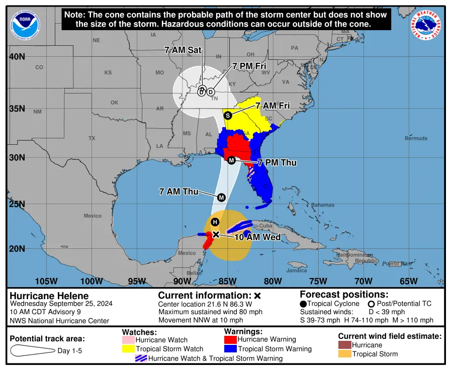
The white cone on an official NHC graphic is a track forecast cone. It is built around the likely path of the storm center, not around the outer edge of damaging conditions. The NHC specifically warns that hazards can extend outside the cone, including storm surge, rainfall flooding, tornadoes, and winds.[2]
That distinction matters at the kitchen-table level. A daughter who texts, “Mom is just outside the cone, so maybe she can wait,” is using the graphic for a job it was not designed to do. The question is not whether a house is inside the white shape. The question is whether the older adult’s location is in a watch or warning area, in an evacuation zone, exposed to surge or flooding, or dependent on services that could fail before conditions peak.
- What the cone tells you: the probable area for the storm center’s track, based on past forecast error.
- What it does not tell you: the full size of the storm, the edge of dangerous wind, the reach of storm surge, rainfall totals, tornado risk, road safety, power outage duration, or whether an older adult can safely wait.
- What seniors should do with it: start the medication, transportation, documents, assistive-device, and go-bag work while there is still daylight, fuel, pharmacy access, and caregiver availability.
The hazard may be outside the drawn line
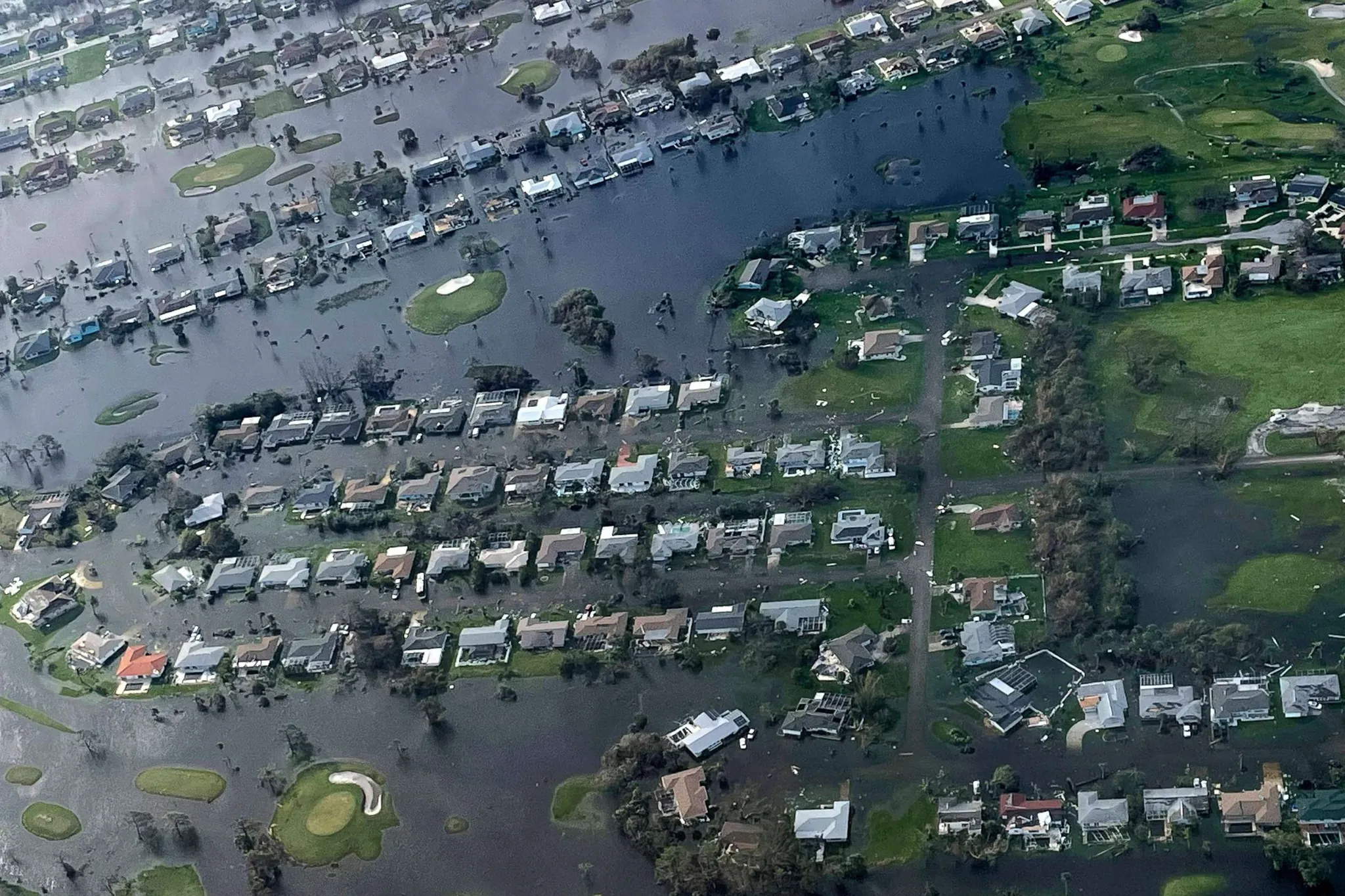
Storm surge is the easiest way to see why cone-only decisions fail. The NHC describes storm surge as the greatest threat to life and property from a hurricane, and it can occur well away from the center track depending on storm size, angle of approach, coastline shape, tide, and local elevation.[2]
Hurricane Ian in 2022 is the case worth keeping in mind. Surge flooding affected areas to the right of the forecast cone, a pattern highlighted in post-Ian explanations of why the cone should not be treated as the whole risk area.[3] Florida’s emergency management guidance also points residents back to surge-based evacuation zones rather than the cone alone, because the zones are designed around who is vulnerable to storm surge flooding.[4]
The misunderstanding is common enough to have a name in weather-risk communication: the “containment effect.” Yale Climate Connections reported that a 2022 survey of more than 2,800 Floridians found nearly half believed the cone showed all possible hurricane tracks.[3] That is an attitude survey, not proof of how every household behaves, but it explains why families keep making the same risky sentence sound reasonable: “We’re outside the cone.”
A senior-specific cone decoder
For an older adult, the cone should translate into work, not waiting. The earlier steps are small, but they protect the margin that disappears when roads fill, pharmacies close, elevators stop, or a caregiver cannot drive through squalls.
| What you see or hear | What it actually means | Senior-safe action |
|---|---|---|
| The cone is near your region, but no local order has been issued | The storm center could come close enough that the forecast deserves attention; it is not a personal evacuation order | Start the 72-to-120-hour preparation clock: medication check, ride plan, device charging, documents, contacts, and go-bag |
| The senior’s home is just outside the cone | Outside the cone does not mean outside the hazard area | Check local watches, warnings, surge maps, flood risk, and evacuation zone before deciding to wait |
| A tropical storm or hurricane watch/warning covers the area | Official local hazard information has become more important than the cone outline | Tighten the plan: confirm transportation, move outdoor obstacles, charge devices, and decide where the senior will sleep if conditions worsen |
| The address is in an ordered evacuation zone | The local evacuation instruction outranks cone position | Leave according to local instructions, using the safest available timing and route for the senior |
| The storm track shifts away | The center forecast changed; other hazards may still remain | Do not unwind the plan until local officials lift warnings, orders, and road restrictions |
The first row is where many families lose time. They wait for certainty because the center line still looks uncertain. But a senior’s problem is rarely the forecast alone. It is the number of steps that must happen before a safe move is possible.
Make the go-or-stay call from zones, warnings, surge risk, and time-to-move
A safer decision starts with the address, not the cone. In Florida’s Know Your Zone system, evacuation zones are labeled A through F, with Zone A generally the most vulnerable and most likely to be evacuated first because of storm surge risk.[4] Other coastal states and counties use their own tools, but the principle is the same: find the official evacuation zone for the actual address where the older adult will ride out the storm.
- Look up the senior’s evacuation zone before a storm is close. Save or print it. Do not rely on memory, neighborhood guesses, or whether a nearby road flooded last time.
- Check current local watches, warnings, evacuation orders, and emergency management updates. The 2026 NHC cone graphic can show land-based watches and warnings, but local instructions still determine what residents should do.
- Ask how much time this specific person needs to move safely. A senior who uses a walker, does not drive at night, depends on refrigerated medication, or needs help transferring into a vehicle has a shorter practical deadline than the forecast map suggests.
- If an evacuation order covers the zone, follow the order regardless of whether the address appears inside or outside the cone.
The American Red Cross tells older adults to prepare for their specific needs, including keeping a 30-day supply of medications when possible and packing extra assistive items such as eyeglasses, hearing aids, batteries, canes, or other mobility aids.[5] Ready.gov frames older-adult preparedness around three practical steps: assess needs, make a plan, and engage a support network.[6] That framework is exactly what a cone should trigger.
The reason to start early is not that every older adult must evacuate whenever a cone appears nearby. Many seniors can safely stay home for some storms if they are outside evacuation zones, have a sturdy and accessible home, have backup power or cooling plans when needed, and are following local instructions. The reason to start early is that seniors have less room for a late pivot.
Older adults have been heavily represented in some past hurricane deaths. AARP reported that people age 75 and older were about 6% of New Orleans’ population but about half of Hurricane Katrina deaths, and that 61 of 87 Hurricane Ian deaths with known ages were among people age 60 and older.[7] Those figures come from different storms and should not be treated as a universal death-rate formula. They do, however, support a practical rule: do not make the slowest person in the household act on the fastest timeline.
If the senior is outside the cone but inside a risk area
Treat “outside the cone” as incomplete information. If the address is in a surge zone, low-lying flood area, manufactured home, medically fragile situation, or place where roads flood early, the family should keep moving through the plan. The cone can shift. Watches and warnings can expand. Roads can become unsafe before the worst weather arrives.
This is also where fall prevention belongs in hurricane planning. Rushed preparation creates its own injuries: carrying supplies in bad lighting, stepping over extension cords, moving patio furniture in rain, walking through standing water, or trying to leave after dark. For the home-safety side of storm prep, use the site’s guides on severe-storm fall risk for older adults, hurricane-ready home modifications, and wet-surface safety after heavy rain.
What changed on the 2026 cone graphics
Last verified: August 25, 2026.
For the 2026 hurricane season, NOAA announced that the operational NHC cone graphic would show all land-based tropical storm and hurricane watches and warnings for the continental United States, Hawaii, Puerto Rico, and the U.S. Virgin Islands. The updated graphic uses single shading for watch or warning areas and crosshatching where both tropical storm and hurricane watch or warning conditions overlap.[8]
That is an improvement for families because watches and warnings are now harder to miss on the same graphic. It does not change what the cone is: a forecast area for the storm center. Do not let the cleaner graphic turn into a cleaner mistake.
NOAA and the NHC are also testing an experimental 90% ellipse-based cone graphic in 2026. The experimental product is open for public comment through November 30, 2026.[8][9] Because it is experimental, older adults and caregivers should not treat it as a replacement for official watches, warnings, evacuation zones, or local emergency instructions.

Use the first nearby cone to assign work
Once the cone brings the storm into your region’s planning window, assign tasks instead of debating the line. One person checks the evacuation zone and local emergency management page. One person calls the pharmacy. One person confirms transportation. One person prints or gathers documents. One person checks power-dependent equipment and backup contacts.
- Medication: confirm refills, dosage lists, refrigeration needs, and pharmacy hours.
- Transportation: identify who can drive, what vehicle can carry mobility equipment, and whether the driver can leave before dark.
- Assistive items: pack glasses, hearing aids, chargers, batteries, cane, walker, wheelchair supplies, incontinence supplies, and backup footwear.
- Power-dependent devices: contact the medical provider, power company registration program if available, and backup location before outages begin.
- Documents: keep identification, insurance cards, medication list, emergency contacts, care instructions, and evacuation-zone information in a waterproof folder.
- Communication: decide who calls the senior, who calls the neighbor, who checks official alerts, and who makes the final ride decision.
Keep the deeper hazard plans separate so this decision does not become a pile of half-finished advice. For flood and surge details, use the elderly flood safety checklist for caregivers. For tornado-safe-space choices during tropical systems, use tornado shelter choices for seniors with limited mobility. For heat risk after an outage, use the guide to heat exhaustion and heat stroke in seniors.
The final call is local
A cone near an older adult’s region should make the family act earlier. It should not make the family evacuate automatically, and it should never reassure someone into waiting simply because the house is outside the white outline.
For an older adult, the safest sequence is simple: use the cone to start preparation, use watches and warnings to tighten the plan, use the evacuation zone and surge risk to decide whether to leave, and follow local emergency instructions even when the cone seems to tell a more comfortable story.
References
- Definition of the NHC Track Forecast Cone — National Hurricane Center
- How to Use the Cone Graphic — National Hurricane Center
- Check out the brand-new hurricane cone of uncertainty graphics arriving this season — Yale Climate Connections, May 2026
- Know Your Zone — Florida Division of Emergency Management
- Older Adults — American Red Cross
- Older Adults — Ready.gov
- Disaster Risks to Older Adults — AARP, 2022
- National Hurricane Center to issue new forecast cone graphics for 2026 hurricane season — NOAA, March 24, 2026
- Experimental Cone Graphic — National Hurricane Center
Related reading
Noticed something outdated or inaccurate on this page? Flag a correction. We review every report against CDC, NIA, and AARP HomeFit guidance before updating a page.
Part of the Fall Prevention section.